Urbanie & Urbanus

Issue 2021 Dec
Regeneration
Issue 6, P.79 - P.101
Reimagining Heath Park - A complex systems approach to urban re- generation
Figures
_Location_map_showing_the_site’s_location_within_the_UK’s_Liverpool_City_Region_and_the_proposed_aerial_view_of_the_RIBA_competition-wi.jpg)
Fig.1: (anti-clockwise): Location map showing the site’s location within the UK’s Liverpool City Region and the proposed aerial view of the RIBA competition-winning masterplan for Heath Park.

Fig.2: Complex and interlinked issues of the 21st century.
,.jpg)
Fig.3: ‘Humanity’s 21st century challenge is to ensure that no one falls short on life’s essentials (from food and housing to healthcare and political voice), while ensuring that, collectively, we do not overshoot our pressure on Earth’s life-supporting systems, on which we fundamentally depend – such as a stable climate, fertile soils, and a protective ozone layer’. Source: Diagram adapted from ‘Doughnut Economics’ by Kate Raworth.

Fig.4: Settlements as complex systems with key multiscalar subsystems changing at different rates.

Fig.5: Professional myopia.

Fig.6: Key character areas a. Wildflower Meadow Ride, b. Woodland Copse, c. Wetlands Nature Park, d. Central Boulevards, e. Wet Woodland Belt, f. Activity and Fitness park, g. Entrance Plaza, h. Southern Parkway. Proposed green system as a mosaic of new ecologically-rich productive landscapes
_and_after_illustration_of_the_proposed_Pylon_Meadows_Park..jpg)
Fig.7: Before (inset) and after illustration of the proposed Pylon Meadows Park.

Fig.8: The green system supporting strategic connectivity into the wider context.

Fig.9 : Heath Park’s circular water economy. Living Machine illustration treating waste water on-site
_and_after_illustration_of_the_proposed_Wet_Woodland_Belt.jpg)
Fig.10: Before (inset) and after illustration of the proposed Wet Woodland Belt
_and_proposed_local_space_syntax_analysis_(right)_indicates_how_the_site’s_existing_low_levels_of_connectivity.jpg)
Fig.11: Existing space syntax analysis (left) and proposed local space syntax analysis (right) indicates how the site’s existing low levels of connectivity into the wider context is transformed with a permeable and joined-up street network for walking, cycling and vehicular flows.

Fig.12: Proposed street network with hierarchy of street types and public open spaces.
_and_after_illustration_of_the_proposed_Central_Boulevard.jpg)
Fig.13: Before (inset) and after illustration of the proposed Central Boulevard.

Fig.14: Proposed land use distribution within the masterplan.

Fig.15: Multi-plot perimeter block with private back gardens and a resident-only communal garden.

Fig.16: Refurbish and reuse Heath Park’s existing building stock, unlocking opportunities for affordable incubator spaces.
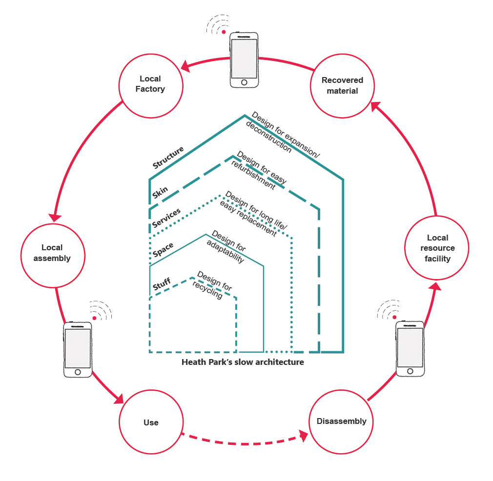
Fig.17: Heath Park’s slow architecture.

Fig.18: Diagrammatic representations of house plans showing grouping of the ‘hard’ services and circulation spaces, within a simple grid structure supporting easy reconfiguration of the ‘soft’ internal spaces and external skin.
 Fig.19: Internally, the main living spaces benefit from multiple focal spaces, such as nooks, bays, and window seats, allowing a variety of individualised activities to take place at the same time and supporting family togetherness.

Fig.20: Regenerative utility loops of energy, water and waste.

Fig.21: Multi-scalar fractal architecture rooted in organised complexity: details within the simple overall forms maintained at every scale – so as you go closer and closer something new is revealed.
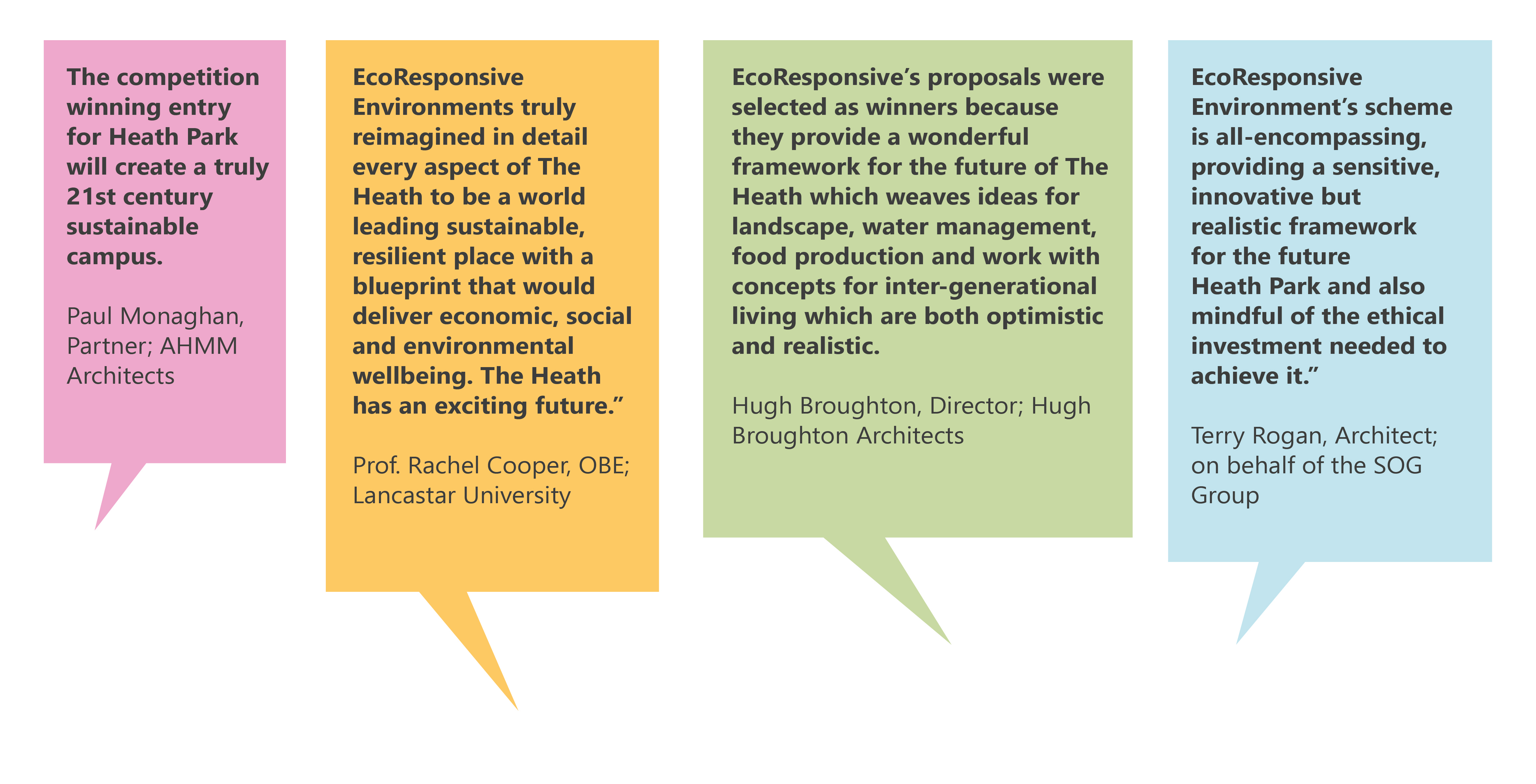
Fig.22: RIBA jury panel comments on Heath Park ‘Vision of the Future’ competition-winning proposals.

Fig.23: Financial value balanced with design values at Heath Park.